


Geophysik von Impaktstrukturen – Einführung
Eine Übersetzung der Seite ins Deutsche ist in Arbeit.
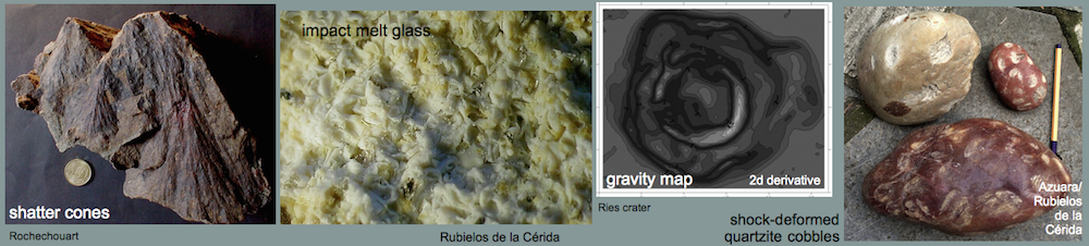
Geophysical measurements have always played a major role in the investigation and study of impact craters (impact structures). Probably, the first surveys were done in the Ries crater in Germany. As early as 1897 (and later in 1922 and 1926) pendulum measurements showed the existence of gravity minima and maxima, partly correlating with magnetic anomalies from measurements published in the year 1904. At that time, the 25 km-diameter Ries (Nördlinger Ries) crater was clearly considered a geological structure that had been formed by endogenetic, very probably volcanic processes.
An early magnetic survey was also performed in the Meteor (Barringer) Crater in 1910. At that time, the origin of the exceptional geologic feature was heavily disputed, and the magnetic measurements were done in order to locate the large iron-metallic projectile at depth – if the crater had been formed by meteorite impact. As we know, the measurements and many boreholes before and after the magnetic survey were without result.
 Fig. 1. Reflection seismics; Ries (Germany) impact structure.
In the second half of the 20th century when the acceptance of the reality of meteorite impacts on Earth grew, the application of geophysical measurements to the study of craters also increased. In many cases, their results were used to argue in favor of one of the disputed hypotheses of formation – endogenetic or by meteorite impact. When in the fifties magnetic surveys revealed strong anomalies in the Ries basin they were attributed to basaltic rocks below the thick Tertiary basin sediments thus obviously proving the volcanic origin of the Ries. 10 – 20 years later, it could be shown that the Ries suevites, by then considered a special variety of volcanic rock, may also be strongly magnetized. Later boreholes in the basin never encountered basalts but always impact suevites as the cause of the measured magnetic anomalies.
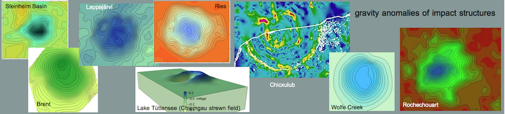
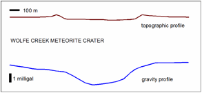 Fig. 2. Gravity profile of the Wolfe Creek crater in Australia. Modified from Fudali (1979).
In one more aspect, geophysical measurements have contributed to impact research that is the discovery of craters deeply buried in and below older sediments. In most cases, reflection seismics carried out for oil and gas exploration purposes could delineate impact structures by their typical structural features like rings, central uplifts and abruptly terminating reflectors, and by reduced seismic velocities due to impact brecciation and micro-fracturing. Also the famous Chicxulub impact structure related with the K/T boundary mass extinction was discovered by geophysics. Only recently, results of satellite gravity measurements and radar imagery have been interpreted to reflect a giant 500 km-diameter impact structure („Wilkes Land crater“) buried beneath the Antarctic ice sheet. (see:http://en.wikipedia.org/wiki/Wilkes_Land_crater)
Here, we focus on the general possibilities of geophysical surveys in impact structures using gravity, geomagnetic, seismic, geoeletrical and geothermal methods illustrated by a few examples from various impact structures.